
Will Climate Change Turn The Arctic Green?
Eddie Gonzales Jr. – MessageToEagle.com – The Arctic region experiences a rate of warming four times greater than any other region on Earth.
This phenomenon has already changed the Arctic Ocean. The sea ice, which once blanketed a vast expanse of the ocean throughout the year, has now become a seasonal occurrence, melting and disappearing from extensive areas during the summer months.

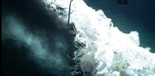
Ice algae growth – Scientists of the University of Tromsø and the BREATHE project deployed BlueEye ROVs under a first-year sea-ice floe that they were drifting with. Here you can see some coloration of the ice algae growth at the bottom of the ice, which appears green here, as well as some deformation/ridging of the ice. Image credit: UiT/BREATHE – ESA Standard Licence
This alarming development underscores the urgency of addressing the escalating impacts of climate change on this fragile ecosystem.
Of the ice that remains, much is thinning, and snow depth is observed to have been declining.
ESA’s CryoSat mission has been a key asset for tracking the Arctic’s melting ice. After 14 years in space, it has one of the longest unbroken records of polar ice thickness in existence.
Now, thanks to research published in Geophysical Research Letters, it can add another string to its bow—measuring light-penetration through Arctic sea ice.
Lighting up the Arctic Ocean
Rapid warming of the Arctic affects the marine ecosystem—and not just polar bears and walruses.
“As ice and snow gets thinner, more light penetrates to the bottom of sea ice,” said Julienne Stroeve of the University of Manitoba and the University of Colorado. “This changing light regime has the potential to impact the entire marine ecosystem, which all begins with algae.”
On the undersurface of the ice, a lawn of algae expands every year. Like open-water phytoplankton, which grow to cover huge expanses of ocean that can be spotted from space, the ice-bound algae bloom over wide areas and support an intricate food web.
As algae bloom, zooplankton graze on them from underneath, which go on to feed a variety of animals including fish, which go on to feed seals, and in turn the polar bears.

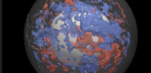
Ice algae blooms from 2011 to 2022. Yearly ice algal bloom onset dates from 2011 to 2022. Blended CryoSat and Sentinel-3 data are for 2019 and 2020 only, extensions with ICESat-2 are outlined in red. Areas in white near the pole have insufficient light to initiate a bloom. Image credit: ESA (Data: CryoSat/Copernicus Sentinel-3/ICESat-2) – ESA Standard Licence
We still have much to learn about how this ecosystem will be affected due to climate change, therefore algae—the primary producers in the ecosystem—are a great place to start.
Mapping that from space has been a challenge.
“Unlike in the open ocean, we can’t see the algae within sea ice from space,” said Karley Campbell of the University of Tromsø. “What we can do is start by estimating light availability. Light, harvested by ice algae to make organic compounds in photosynthesis, is a major factor driving marine production.
“If we can map the light reaching the algae, we can get an idea of when and how much they might bloom.”
To understand that you need to know how thick the ice is, and how much snow is on top. Thicker ice and snow mean less light can reach algae under the ice.
That’s where CryoSat comes in. Along with Copernicus Sentinel-3 and NASA ICESat-2 data, scientists estimated Arctic sea-ice thickness over CryoSat’s
14-year lifetime in orbit.
Applying algorithms to understand how much light penetrates through ice, snow and using models to predict historic snow and ice cover, it was then possible to model where and when algae might start to bloom.
Data from 2011 to 2022 showed more southerly Arctic regions would experience earlier algal blooms, which varied year-on-year. Snow appeared to be a large factor.
The model suggested that a particularly snowy 2017 resulted in a deeper snow cover preventing large areas from blooming due to insufficient light.
Melting snow sparks a bloom
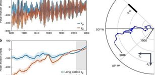
As snow appeared to be a major influence, the researchers examined how declining snow might have affected algal blooms. Since the 1980s, snow depth has been decreasing across most of the Arctic.
After modeling snow depth changes from 1982 to 2018 and combining this with estimates of the light penetrating through the ice, a clear picture emerged.
The model suggested algal blooms starting as much as 15 days earlier per decade in southern regions.
There are many other factors involved. Sediment and ice structure will alter how much light gets through the snow and ice. Other things that might affect algal growth have to also be considered, as well as the effect of the increased availability of light.
Algae bound to ice tend to be natural shade dwellers. Exposed to more light, they might produce different sugars and fats, or die off at different times. All these aspects must be understood to get the full picture.
But the capacity to use satellite measurements to paint a broad picture of photosynthetically active radiation under ice is a hugely useful tool to support other methods for monitoring the Arctic ecosystem.
“This unprecedented use of satellite data benefits our knowledge of the rapidly changing Arctic ecosystem,” said Julienne. “Understanding the photosynthetically active radiation that penetrates sea ice will support wider studies to understand just what is happening to life in the Arctic Ocean due to climate change.”
Considering snow is such a major factor in determining how much sunlight penetrates ice, the collaboration between CryoSat and ICESat-2 known as Cryo2ice should yield further insights.
The two satellites will align almost simultaneously over the Arctic in the winter of 2024, and the combined measurements will give us our best estimate yet of the snow cover on top of ice.
With CryoSat’s radar and ICESat-2’s lidar instruments working in tandem, we will get an insight into the future of ice altimetry. The Copernicus Polar Ice and Snow Topography Altimeter (CRISTAL) mission will use a dual-frequency radar to accurately map snow depth on sea ice, continuing the satellite record of polar ice well into the 2030s.
“After 14 years it’s wonderful to see that CryoSat keeps on finding new applications,” says CryoSat Mission Manager, Tommaso Parrinello. “The rapid changes happening in the Arctic will have widespread consequences that affect all of us.
Maintaining long-term satellite records is vital to help us understand them and navigate the future. I’m excited to see the impacts of the Cryo2ice collaboration in the coming months and years as well as the CRISTAL mission that will maintain the climate record beyond CryoSat.”
source – ESA
Written by Eddie Gonzales Jr. – MessageToEagle.com Staff Writer
Related Posts
-
 Crevasse Icequakes On Alpine Glacier Detected By Fiber Optic Cable On Glacier
-
 Geologists Update Textbooks With New Insights From Grand Canyon Cambrian Rocks
-
 Sunken Worlds Under The Pacific? Current Understanding Of Plate Tectonics – Questioned
-
 Investigating New Hydrothermal Vents 3, 000 Meters Deep Off Svalbard
-
 Research Reveals How Earth Got Its Ice Caps
-
 Greenland Megatsunami Caused Week-Long Fjord Wave
-
 Steady Increase In Deep-Ocean Warming Clearly Seen In Robot Data
-
 Climate Change’s Impact On Earth’s Rotation
-
 Earth’s ‘Dirty Mirror’ Effect Accelerates Climate Change
-
 A New Mechanism To Explain How Continents Stabilized