Massive Ancient Ocean Floor And Giant Underground ‘Mountains’ Discovered Near Earth’s Core
Eddie Gonzales Jr. – MessageToEagle.com – Through global-scale seismic imaging, scientists have discovered massive ancient ocean floor surrounds the Earth’s core. Near this dense, thin, sunk ocean floor, there are also giant underground ‘mountains” up to 5 times taller than Mt. Everest. Scientists have studied how this ancient ocean layer, located about 2,000 miles (3,200 kilometers) below Earth’s surface, between the core and the planet’s middle layer, called the mantle.
The Ancient Structure Is More Complicated Than Previously Thought
Seen only in isolated patches previously, the latest data suggests this layer of ancient ocean floor may cover the core-mantle boundary. Subducted underground long ago as the Earth’s plates shifted, this ultra-low velocity zone, or ULVZ, is denser than the rest of the deep mantle, slowing seismic waves reverberating beneath the surface.
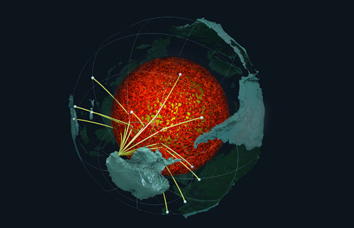
Seismic waves from earthquakes in the southern hemisphere sample the ULVZ structure along the Earth’s CMB and are recorded by sensors in Antarctica. Credit: Edward Garnero and Mingming Li, Arizona State University.
“Seismic investigations, such as ours, provide the highest resolution imaging of the interior structure of our planet, and we are finding that this structure is vastly more complicated than once thought,” said Dr. Samantha Hansen, the George Lindahl III Endowed Professor in geological sciences at UA and lead author of the study.
“Our research provides important connections between shallow and deep Earth structure and the overall processes driving our planet.”
Investigating Anomalous Zones Beneath The Earth
These subtle signals were used to map a variable layer of material across the study region that is pencil thin, measuring in the tens of kilometers, compared to the thickness of the Earth’s dominant layers. The properties of the anomalous core-mantle boundary coating include strong wave speed reductions, leading to the name of ultra-low velocity zone.
ULVZs can be well explained by former oceanic seafloors that sunk to the core-mantle boundary. Oceanic material is carried into the interior of the planet where two tectonic plates meet and one dives beneath the other, known as subduction zones. Accumulations of subducted oceanic material collect along the core-mantle boundary and are pushed by the slowly flowing rock in the mantle over geologic time. The distribution and variability of such material explains the range of observed ULVZ properties.
The ULVZs can be thought of as mountains along the core-mantle boundary, with heights ranging from less than about 3 miles to more than 25 miles.
“Analyzing 1000’s of seismic recordings from Antarctica, our high-definition imaging method found thin anomalous zones of material at the CMB everywhere we probed,” said Garnero. “The material’s thickness varies from a few kilometers to 10’s of kilometers. This suggests we are seeing mountains on the core, in some places up to 5 times taller than Mt. Everest.”
These underground “mountains” may play an important role in how heat escapes from the core, the portion of the planet that powers the magnetic field. Material from the ancient ocean floors can also become entrained in mantle plumes, or hot spots, that travel back to the surface through volcanic eruptions.
Along with Hansen, co-authors on the paper include Drs. Edward Garnero, Mingming Li and Sang-Heon Shim from Arizona State University and Dr. Sebastian Rost from the University of Leeds in the United Kingdom.
Roughly 2,000 miles below the surface, Earth’s rocky mantle meets the molten, metallic outer core. The changes in physical properties across this boundary are greater than those between the solid rock on the surface and the air above it.
Earth core. Inner structure with geological layers. Credit: Adobe Stock – 3D motion
Understanding the composition of the core-mantle boundary on a large scale is difficult, but a seismic network deployed by Hansen, her students and others during four trips to Antarctica collected data for three years. Similar to a medical scan of the body, the 15 stations in the network buried in Antarctica used seismic waves created by earthquakes from around the globe to create an image of the Earth below.
The project was able to probe in high-resolution a large portion of the southern hemisphere for the first time using a detailed method that examines sound wave echoes from the core-mantle boundary. Hansen and the international team identified unexpected energy in the seismic data that arrives within several seconds of the boundary-reflected wave.
The study was published in the journal Science Advances.
Written by Eddie Gonzales Jr. – MessageToEagle.com Staff

