AI Discovers Hundreds Of Unusual Nazca Geoglyphs In The Desert
Jan Bartek – MessageToEagle.com – Since their initial discovery in 1927, scientists have identified 430 figurative Nazca geoglyphs across over 130 miles of desert. These geoglyphs are smaller and older than the Nazca lines.
Geoglyphs are large designs or motifs created on the ground by rearranging surface stones or gravel, and they are prominently found across the Nazca Pampa. Situated approximately 50 kilometers inland from Peru’s southern coast, these geoglyphs lie on a desert plateau about 500 meters above sea level. Their longevity is attributed to their location in an area not prone to flooding and unsuitable for agriculture, allowing them to endure through the ages.
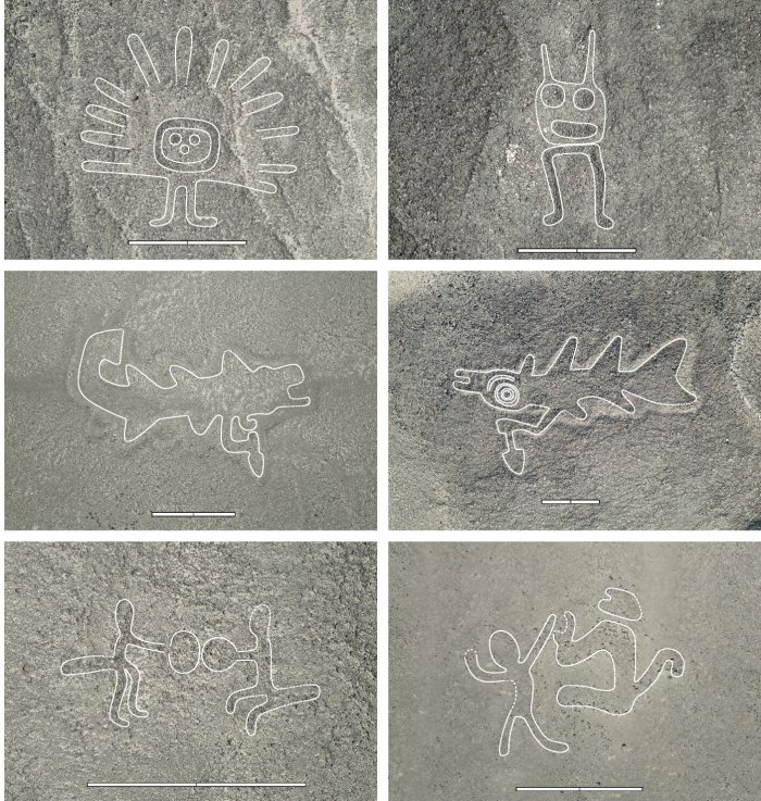
Fifteen of a total of 303 newly discovered relief-type figurative geoglyphs from the AI-assisted survey. Drone images taken during the field survey that confirmed the geoglyphs as authentic. The scale bars are 5 m. Outlines have been added as a guide to the eye. The figurative geoglyphs depict humanoids, head, domesticated animal (camelid), killer whales, birds, feline, ceremonial scene, and human/animal interaction. Credit: Sakai et al., PNAS, 2024
These formations offer archaeologists valuable insights into the cultures and beliefs of ancient civilizations that began using them over 2,000 years ago, but finding the geoglyphs takes a long time. However, AI has now significantly accelerated this decoding process.
Recently, archaeologists from Yamagata University in Japan and researchers from IBM have leveraged artificial intelligence to uncover hundreds more large-scale drawings. Among these unusual depictions are figures such as llamas, decapitated human heads, and killer whales wielding knives.
These new symbols were created by the early South American Nazca people between 200 BC and 500 AD.
According to Masato Sakai, the lead author of a recent study, artificial intelligence has played a significant role in identifying over half of the newly discovered symbols. Sakai and his team utilized AI to locate smaller geoglyphs by training a model to analyze aerial photographs. These high-resolution images covered an area approximately ten times the size of Manhattan, including the Nazca Pampa desert plateau and its surroundings, part of the UNESCO World Heritage Site known for the Nazca lines. The AI-generated a gridded map that assessed the likelihood of each grid square containing geoglyphs.
Credit: Sakai et al., PNAS, 2024
Despite limited training, AI effectively detected smaller relief-type lines, which average about nine meters long, compared to major Nazca lines, which are around 90 meters long. This research is detailed in their study published in PNAS. Masato Sakai from Yamagata University also highlights cultural insights from pottery depicting orcas with knives decapitating humans during the Nazca period, suggesting orcas were perceived as entities involved in human sacrifice.
What Was The Purpose Of The Nazca Geoglyphs?
“As to the purpose of the geoglyph construction, there are at least five distinct, if not totally unrelated, hypotheses These are i) calendar and astronomy, ii) geometry, iii) agriculture and irrigation, iv) movement or communication, including walking, running, and dancing, and v) artistic expression. The predominant opinion is that linear geoglyphs “were an integral part of the Nasca sacred space,”” the study’s authors write.
Numerous lines either radiate from or converge at a central point, with some linked to pilgrimage routes to and from Cahuachi, socioreligious territories of specific social groups, or subterranean water sources.
See also: More Archaeology News
Similarly, in Peru’s Chincha Valley on the south coast, paired line segments marked the setting sun during the June solstice and formed part of a trade route. The hypothesis that line-type figurative geoglyphs relate to calendars and astronomy has garnered interest. It suggests that animal-shaped geoglyphs correspond to constellations; however, this idea has faced criticism for relying on a Western interpretation of constellations without ethnohistorical or ethnographic support. Relief-type geoglyphs might have been designed for distant viewing since they are often found on hill slopes where they can be seen from afar.
Preserving The Nazca Geoglyphs For Future Generations
“Nazca geoglyphs are part of the human cultural heritage, and they are protected by the UNESCO and the Peruvian Ministry of Culture. Accidental or malicious destruction of geoglyphs has been occurring in the past. Climate change poses new threats to Nazca geoglyphs today, amplifying extreme weather events and potentially triggering more devastating flash floods in desert areas. We hope that efforts like ours to accelerate geoglyph identification and documentation with the help of AI may lead to better strategies to mitigate damage and manage cultural resources in desert environments,” the research team says.
The study was published in the journal PNAS
Written by Jan Bartek – MessageToEagle.com – AncientPages.com Staff Writer


